I’m keen to try to get out into the hills a bit more often and with the cold but dry weather conditions being so much more suited to hiking than those in the summer I decided to stay over in Wonju after a basketball game and hike the following day in the Chiaksan National Park. I’d been to Chiaksan before, in January 2011, and remembered it as being a decent day out.
Jen and I took a twenty minute taxi ride to the park entrance and by a quarter to nine we’d set off. You don’t have to walk for too long before you reach Guryongsa temple. We didn’t bother going for a nose around, but we did see the bloke in front bowing as he went past. He didn’t seem too fussy about what he bowed to though as a few moments later he seemed to be paying his respects to a bush.

Guryongsa Temple
The hike to the 1288m Birobong peak was fairly easy going for the first hour or so, although with snow on the ground there were a few slippery sections. Upon reaching the Seryeom waterfall we were given a choice of two trails.

Last time I took the Sadaribyeongchang route and so this time we went the other way along the Gyegokil trail. There was a very handy gradient guide which seemed to confirm that it didn’t really matter which way we went.

Equally steep.
Our route took us via a valley and for a lot of the way we could see and hear the people who had taken the ridge route. They had gained ground a lot quicker than we did, although all that meant really was that we would have it to do as we got closer to the top.
It seemed that far fewer people were taking the Gyegokil option and a lot of the snow was relatively undisturbed. Walking poles made it a lot easier to stay upright.

I was lagging behind at this point.
The temperature was a little below freezing. It wasn’t as cold as the last time I’d been to Chiaksan, but it was cold enough to have frozen most of the river that should have been flowing in the valley. We had to walk across ice a couple of times when the path briefly followed the water, but even though the water was still running below the surface it was solid enough to support us.

I was less sure that it would take my weight.
The highlight of the day for me was feeding some birds halfway up. We watched a bloke enticing them down from the trees to feed from his hand and by giving up half a cereal bar I was able to do the same.
I dare say there isn’t a great deal of food around when the snow is on the ground and five or six different birds took the opportunity to take food from me.

Just like Trafalgar Square used to be.
I’m no ornithologist, so haven’t the slightest idea of what birds they were. Tits probably. If I call them Korean tits I can almost certainly increase the blog traffic from the search engines. They were quite small Korean tits as opposed to big Korean tits. You might even call them perky Korean tits.
It was fun feeding them and I’d have quite happily given up the rest of my lunch if we’d had the time to stand around whilst they ate it.

A different one.
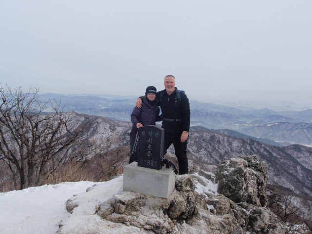
As we got higher the snow got thicker and there were sections where we had to haul ourselves up using ropes and railings. Four hours after setting off we reached the top. It was busy, with far more people appearing to have taken the Sadribyeongchang route. The views were good though, the various ridges that disappeared into the distance looking a lot more interesting without their usual covering of foliage.
Chiaksan is the place where that fella built three big cairns at the top fifty years ago. Pointless but impressive.

You can see two of them here, the third was behind me.
Getting back down afterwards was tricky, even with spikes and poles. The ropes helped a lot, but couldn’t prevent a few slips. It took us two hours to get back to the waterfall and then another hour to reach the car park. There weren’t any taxis waiting but we managed to get a bus within fifteen minutes or so. They look as if they run quite frequently until late in the evening and the one that we caught had us at Wonju railway station in about half an hour. Unfortunately all the trains were fully booked and so we had to take at taxi to the bus station where it was easy enough to get a seat on a bus back to Seoul.

Bus timetable at Guryongsa car park.
It wasn’t a long hike in terms of distance, maybe six kilometres each way car park to car park, but it gained enough height to make it hard work in the snow. There are other routes that go on from the Birobong peak to the other side of the park and I reckon that with an early start and good weather it would be possible to hike from one side to the other.
I doubt we’ll get around to it, but then again I hadn’t expected to return to Chiaksan at all, so you never know.

January 21, 2013 at 12:57 pm |
Definitely a Korean Thrush….. that should help the traffic.
January 21, 2013 at 1:04 pm |
It should. I was worried that you were dead at the weekend. Was it anywhere near where you were at the week before?
January 24, 2013 at 1:43 pm |
It was in the very next gully, we’d taken a look down that one and thought better of it. I did manage to climb No5 gully on The Ben the day before that was fantastic as we were pretty much front pointing on crampons for some sections.
Anyway safe and well 🙂
February 7, 2013 at 2:11 am |
I saw a bumper sectkir that read: stop this endless war but had the end part marked off and the word use written above it. I like the one that reads: 01-20-09 the end of an error.OOps I forget to add .net at the end of my e-mail address and now I have to type the whole thing over again, arrrrgh!
February 7, 2013 at 8:37 am |
ifAPCU wdiadbgijjqa